Homework help for Year 10 1st December 2014 Tropical Storms
There are three steps that people are urged
to follow to reduce the damage from tropical storms:
FORECAST - PREPARE - ACT
Forecast
Most countries affected by tropical storms
now have education programmes to raise awareness on preparing for
storms. There is an annual Hurricane Preparedness Week in the USA when
schools, businesses and families are all encouraged to plan for possible
strikes in the forthcoming hurricane season. Leaflets, posters and school
lessons are common ways of spreading the message. New technologies - such
as Twitter are also being used to educate people.
People living in areas affected by tropical storms are encouraged to
have a hurricane emergency kit on standby and also to have
thought in advance about how they will protect their home and belongings. This
might include boarding up windows and doors. In MEDCS, people may also be able
to afford windproof tiles, water-resistant windows and strengthened building
structures.
People in LEDCs may not be able to afford this kind of protection.
However, simple but cheap measures can be put in place to ensure that people
are well prepared for tropical storms. These include educating people
(particularly women) about what to wear in case they have to
swim, building homes on stilts, building cyclone
shelters and training local people to organise others in an evacuation.
Act
Volcanoes
How can people plan and prepare for a volcanic
eruption?
If an eruption is predicted, access
to the volcano may be restricted or the area might be evacuated
(i.e. people moved away to a place of safety). We looked at the example of Chances
Peak in Montserrat - the island is zoned
into evacuation 'no-go' zones and areas where people can stay but need to be
ready to leave quickly. When the volcano started erupting in 1995, access to
the south of the island was restricted and around 5000 people were evacuated to
the northern part of the island where a new port area was built at Little Bay
to allow people to leave the island. The volcano is still erupting, and the
island zone map and hazard level classification system is shown below.
When lava flows are threatening a town or
village, it may be worth the expense of building earth
or rock walls to divert lava flow or even using planes and
helicopters to drop water to cool the lava and
slow it down. This happened in Iceland in 1983. The military might be called in
to use bombs and dynamite to alter the flow of the lava
(these techniques have been used by the Italian authorities when managing Mount
Etna).
In areas where volcanoes give out large amounts
of ash, building design can help to limit the damage caused by an eruption.
Flat-roofs are a major risk as ash settles on them and becomes very heavy,
causing collapse. Sloping roofs are much better,
particularly if they can be made from smooth materials such as metal and glass
which are more likely to shed the volcanic ash. People living in affected areas
should also make sure that doors and windows have a good
seal and that filter systems are installed to
limit ash damage to computer and electrical systems.
Residents
should keep an emergency kit - water, tinned
food, wind-up radio, tape, towels, googles, torch, breathing mask - in case the
volcano erupts. Campaigns in areas subject to eruptions have helped to educate
people about the importance of keeping an eruption kit. In some areas, practice drills are held to make sure that everyone knows
what to do in an eruption. Evacuation
routes
can be planned and tested, and signposts can help to inform people of escape
routes. Volcanic hazard maps can also be used
to help predict the likely consequences of an eruption.
Stop the disaster Home work Click on the link and play the game. When finished write 200 words on other ways to protect people in earthquake zones. Check out the documentary on wild fires folks, it'll help with the hostiles world unit! http://www.bbc.co.uk/iplayer/episodes/b046tbjs Jan 8 the disappearing stack http://www.bbc.co.uk/news/uk-25639777 just loving this song ….. Medmerry's £28m flood prevention scheme set for completion today
http://www.bbc.co.uk/news/uk-24801323
Year 10 Mock Summer Examination
1 hr 30 min
Section A: Coastal Environments
Section B: Living with Natural Hazards
What do you need to know...? The range of economic activities found in coastal areas How are coasts sustainably managed? Features and processes of soft coastlines Coastal management Short and long term reponses to volcanoes How earthquake impacts can be reduced Tropical revolving storms Reduction of wildfires Year 10 Revision Ideas...
Some sample past questions on Coastal Environments
1 (a) (i) Suggest two ways that the natural environment attracts tourists to the coast of
1 (a) (ii) Explain how coastal areas can provide opportunities for economic development. (4 marks)
1 (b) (i) Explain how the development of coastal areas can damage local environments. (6 marks)
1 (b) (ii) Suggest how a coastal area could be protected from over-development. (4 marks)
1 (c) (i) Name and describe one process of coastal erosion.
(2 marks)
1 (c) (ii) Name and describe one process of weathering in coastal areas.
(2 marks)
1 (e) Explain the formation of a coastal bar. You may use a diagram to support your answer. (6 marks)
Year 10 Mock Summer Examination
1 hr 30 min
Section A: Coastal Environments
Section B: Living with Natural Hazards
|
Controlled Assessment:
Year 10 Easter Holiday Research
Below are some resources which should help you understand thebackground theory to controlled assessment task 2: 'Water a precious resource'. Year 10 will be starting the controlled assessment task after the Easter holiday.
A Chinese website outlining the importance of water...
Very useful starting point...
Water management in LEDCs
Water management in LEDCs
Consider how water is used differently in LEDCs and MEDCs and how this can impact economy and social development...
Remember Year 10 Geography Exam in Summer. Revision sessions will be provided nearer the time...
El Nino information. Consider how it would influence Tropical Revolving Storms? Check out link...
Year 10 Hurricane Exam Question
Deadline Tuesday 26th February 2013
Question: Study Figure 1, which shows information on the USA and Myanmar (Burma).
•
With the help of Fig 1, explain why the people of the USA may be better prepared for a tropical storm than the people of Myanmar.
Fig 1: Indicator
|
Myanmar
|
USA
|
Birth Rates (per 1000)
|
17
|
14
|
Death Rates (per 1000)
|
9
|
8
|
GDP (per person)
|
$1,900
|
$46,000
|
Life expectancy (years)
|
62
|
79
|
Literacy rate (%)
|
90
|
99
|
Employment structure
|
Primary: 54,
Secondary: 10,
Tertiary: 36
|
Primary: 2,
Secondary: 20,
Tertiary: 78
|
Internet users (%)
|
0.6
|
68
|
Mobile phone users
|
0.4
|
77
|
.......................
Year 10 Hurricane Case Study. Study the following links. What are the key differences between reponses to hurricanes in a LEDC and a MEDC?
Case Study on Hurricane Katrina 2005
Case Study on Hurricane Nargis 2008
What can be done to reduce the impacts of Volcanoes?
Prediction
Technological advances are making it easier to predict volcanic eruptions.
|
Preparation
Being able to predict volcanic eruptions makes it easier to prepare for them
|
•
Hostile Worlds Unit 2: Year 10 Homework
Use the website to produce a 200 word summary describing how USA citizens are encouraged to prepare for earthquakes
•
Include 30 words evaluating how useful the website is. Check out this Case Study of Monserratt eruption in 1997
Year 10! Watch the news reports on Wildfires and consider the primary and secondary effects.
Check out the Tsunami 2004 Story in Impossible...
10F Hannah Cairns
10O Eleanor Gray, Kirsten Davis, Chloe Highton
10R Neil Kinrade and Aidan Kirwin
10M Charlie Hinchy, Grace Halton, James Bamber,
10B Eleanor Sutton and Elizabeth Green
10Y Lucy Carr, Lucy Edmondson, Lucy Fell
The above students have agreed to co-ordinate a collection of goods for Asylum Links following the recent session on Rainbow Day. Thank you for all your offers of help. Your response has been overwhelming!
The following items are particularly needed at the centre. I can drop these off on Friday 21st December so please give them to your tutor representatives by Wednesday 19th December during morning tutor period.
· All unwanted clothing (in good condition!) particularly men’s clothing.
· Toiletries such as, shampoos, shower gel, razor blades, soaps etc.
· Food stuffs (in date!);
Sugar
Tea
Coffee
Cooking Oil
Rice
Tinned Tomatoes
Tuna
Corn Beef
Beans/Soups/Spaghetti are welcomed but not in demand.
Thank you for all your hard work. Any questions see Mrs Slater in C14.
What a fascinating and emotional Rainbow Day Year 10
Here is the link for Asylum Links website should you wish to investigate further...Well done for all your hard work and maturity.
Mrs S x
http://www.bbc.co.uk/learningzone/clips/the-impact-of-mass-tourism-in-spain/1569.html

Can you guess what it is? Where it is?
Question: What is the difference between a spit and a bar?
Answer: A bar develops by the process of Longshore drift,which occurs due to waves meeting at the beach at an angle and backwashing perpendicular to the shore, moving sediment down the beach on a zigzag pattern whereas, a spit is a deposition landform found off coasts. At one end, spits connect to land and extend into the sea.
Well done to Mrs Slater's AMAZING Year 10 class.
Fabulous 3D Coastal Landforms.

Read more on Dorset's eroding coastline...
Year 10 Extended Homework Task Due in: Week after half term
Case Study: The Holderness Coastline
The main direction(s) of the prevailing wind- Maps to show the location in the
The areas of coastline exposed to transportation- The areas of coastline exposed to deposition
- The geology of the coastline
The landforms created from erosion (inc. stacks,and wave-cut platforms)
- The landforms created from deposition (inc spit)
REMEMBER TO REFERENCE YOUR WORK AND NO COPY/PASTE!
Here he is...Old Harry, Dorset.
Case Study of a coastal arch- Durdle Door, Dorset...lovely!
Coastal Landforms and Processes
Some preparation for Year 10 Geographers
Welcome Year 10 Geographers 2012!
Take a look at this clip on rip currents. Hope it answers a question that we were discussing today...

Take a look at this diagram on how tides are created?
Link for Y10 homework question
Sunday
Last Day panic!!
Use your revision guide ....
check over the earlier posts on the blog
practice your past questions
Will see you all tommorow - -sleep well and walk to school to gain your brain working ...
Good Luck .......
Saturday
What are the advantages of living in earthquake zones and areas close to volcanoes?
Geothermal energy
Geothermal energy is where steam from water heated by hot rocks below the surface of the earth is used to drive turbines and generate electricity. This is a very cheap and sustainable way of producing electricity since it uses a renewable source. More than 70% of the homes in Iceland are heated by geothrmal energy.
Tourism
Volcanic landscapes often have very beautiful scenery. They attract a whole range of visitors from students on geography fieldtrips to artists, photographers, walkers etc. Tourists migh come to watch eruptions, see geysers, relax in hot springs or have mud baths (we hope to do all of these things on the GCE Geography fieldtrip to Iceland!). The tourism industry that builds up in the area can provide many jobs and these encourage people to live in the area. Thse include jobs as gudies, in visitor centres, in hotels and other types of accommodation as well as in gift shops, cafes. bars etc.
Fertile soils
The volcanic rocks are very rich in minerals. They form fertile soils when weathered, and these are ideal for growing crops. On Mount Etna in Sicily, yields of grapes are five times higher than the national average because the soils are so fertile.
Raw materials and minerals
Many valuable minerals are erupted from volcanoes and these can be collected and used. Gold, silver, copper and tin are found in the remains of extinct volcanoes. In active areas, heated groundwater concentrates traces of these minerals into rich veins which can then be mined.
Why do people still live in danger zones?
Many people choose to live in these areas because of the benefits listed above but a great deal of others stay because they unable to relocate away from the danger zones. For many people, the advantages of living in a danger zone by far outweigh the risk of coping with the possibility of an earthquake or eruption. Make sure you know the reasons listed below as well as the benefits listed above!
- some people think that disasters only affect other people and will never harm them - they ignore the dangers and assume they will be OK
- some people come from families who have lived in danger areas for many many years - long before they knew that they were hazard zones - and they don't want to break family ties by moving away
- some people think that scientists will be able to predict any seismic activity long enough in advance for the area to be evacuated - so they feel safe to live there
- some people simply may not be able to afford to move anywheere else
- some of the settlements in danger zones eg. Mexico ity, San Francisco, Los Angeles, have grown into enormous megacities and there just isn't space to rebuild them elsewhere away from danger
Friday
Hope Chemistry went well - couldn't get paper photocopied in time so you can access it on the following website:
http://web.aqa.org.uk/qual/newgcses/geo_landt/new/geography_b_materials.php?id=09&prev=09
we are sitting unit 2
Tonight you could look at volcanoes ....
Composite volcanoes
- Composite volcanoes happen where the lava is acidic.
- The sticky acidic lava pours slowly down the side of the cone and cools quickly to produce a steep sided volcano.
- Alternate layers are formed because each eruption first produces rock fragments which are later covered by lava.
- This kind of volcano is found at destructive plate margins.

Shield (basic) volcanoes
- Shield volcanoes are enormous features built up only from layers of lava.
- They produce lots of lava but they tend not to erupt violently. Shield volcanoes form when the lava is basic (the opposite to acidic).
- You get these types of volcanoes along constructive plate margins and also where there are hotspots. Basic lava is runny so it flows quite a long way before it cools.

The effects of volcanic eruptions
The effects of volcanic eruptions can be divided into primary and secondary effects.
The primary effects are immediate and come from the eruption itself whereas the secondary effects result from the primary effects.

Primary effects of a volcanic eruption
You need to learn the definitions of the terms volcanic gases; lava flows; pyroclastic flows; tephra.
- Volcanic gases - All magma contains dissolved gases that are release during and between eruptions. These gases are mainly steam, carbon dioxide and compounds of sulphur and chlorine.
- Lava flows - These are streams of molten rock.
- Pyroclastic flows - These are high speed avalanches of hot ash, rock fragments and gas which move down the sides of a volcano. These flows occur when the vent area or ash column collapses.
Secondary effects of a volcanic eruption
Make sure that you know at least 3 secondary effects of an eruption in detail.
- Lahars - These are mixtures of water, rock, ash, sand and mud that originate from the slopes of a volcano. Lahars often happen because of heavy rainfall eroding volcanic deposits or heat from a volcanic vent suddenly melting snow and ice.
- Landslides - Heat from cooling magma can cause hydrothermal alteraton of the rocks, turning sections of them into clay. This weakens the rocks and increases the risk of slope failures.
- Flooding - Explosive eruptions can change thge surface areas around a volcano and disrupt drainage patterns, leading to long-term flooding.
Other secondary effects include:
- Food / water supply interrupted.
- Homelessness.
- Businesses forced to close.
- Cost of insurance claims.
- Unemployment.
- Long-term issues with the tourism industry.
Thursday
What is a tropical storm? How do they form?
- Tropical cyclones use warm, moist air as fuel. That is why they form only over warm ocean waters near the equator.
- The warm, moist air over the ocean rises rapidly upward from near the surface and becomes saturated with evaporated moisture. This means that there is less air left at the surface (i.e. low pressure).
- Air from surrounding areas with higher air pressure pushes in to the low pressure area to try to equalise the pressure.
- Then that “new” air becomes warm and moist and rises, too.
- As the warm air continues to rise, the surrounding air swirls in to take its place. Trade winds cause the moist air to spin inwards.
- As the warmed, moist air rises and cools off, the water in the air forms towering cumulonimbus thunderclouds (because there is a huge amount of condensation).
- The whole system of clouds and wind spins and grows, fed by the ocean’s heat and water evaporating from the surface.
Wednesday
Make sure that you are know the difference between latitude and longitude .....
also check out climate graphs
and other graphs that could come up ...
Tuesday
Revision after school tomo night - don't forget
Earthquakes ...
- Earthquakes are usually caused when rock underground suddenly breaks along a fault.
- This sudden release of energy causes the seismic waves that make the ground shake. When two blocks of rock or two plates are rubbing against each other, they stick a little.
- They don't just slide smoothly; the rocks catch on each other.
- The rocks are still pushing against each other, but not moving. After a while, the rocks break because of all the pressure that's built up.
- When the rocks break, the earthquake occurs.
- During the earthquake and afterward, the plates or blocks of rock start moving, and they continue to move until they get stuck again.
- The spot underground where the rock breaks is called the focus of the earthquake.
- The place right above the focus (on top of the ground) is called the epicenter of the earthquake.
Monday
Have a look tonight at your case study on wildfires in California -make sure you know the effects below:
Effects
The fires forced approximately 1,000,000 people to evacuate their homes, the largest evacuation in California's history.
Over 1800 homes were destroyed.
Over 2,000 km² of land burned.
Nine people died as a direct result of the fires. 85 others were injured, including at least 61 firefighters.
Damage to property estimated at US$1.6 billion.
Air pollution levels raised across the area to 3 times their normal level - this causes breathing difficulties. People were advised to stay indoors.
Tourist trade was damaged. San Diego Zoo and Sea World were closed.
Drinking water in some cities was pollutd and people were advised to drink only bottled water.
Crops were destroyed, either by the fire itself or because they weren't watered as the farm workers had been evacuated. Food prices rose.
Many species of plants and animals were killed.
Sunday
Wildfires throughout colorado and New Mexico forcing evacuations - can you pick out the causes? the effects? How the wildfires are being managed?
http://www.foxnews.com/us/2012/06/10/wildfires-in-colorado-and-new-mexico-forcing-evacuations-destroying-structures/
Monday
A very jubilicious hello!
Sorted wifi and can now nag you from afar!!!
If you get chance today look at your case studies - make sure that you know about Kobe - a tectonic hazard in an MEDC- try to learn 5 key facts that would show the examiner that you are talking specifically about Kobe (the thumb test ). Remember we also studies Monsterrat for a tectonic hazard in an LEDC.
Monday
Use the FEMA website to find ways to prepare for a wildfire in the USA...
http://www.ready.gov/wildfiresSunday
Hope you've been enjoying the hot weather this weekend - perfect wildfire conditions if the hot temperatures continue . Can you answer the following past question ...
Wildfires are more a human hazard than a natural hazard . Discuss. ( 8 marks)
Thursday
What are the advantages of living near volcanoes ?
If your not sure how you would answer this question then watch the video below.....
.......not sure about the music choice but the video is good!
Wednesday
Loving Mr Serabian
Tuesday
Constructive plate boundaries for revision today
I've remarked all your mocks - FANTASTIC BIG BIG BIG IMPROVEMENTS!!!!
Monday
Wildfires
Wildfires in Arizona .....happening now as we sit learning (hopefully) about them -Good luck with english exam tuesday !
Sunday
wildfires
fabulous website for tonights revision
Tuesday 15th May
don't forget to start your 20 minutes a day Y10 ....
Y10 revision guide
Hi chaps you should be able to download the revision guide using this link...
http://www.4shared.com/office/z4fFEgYs/Hostile_World_foundation_guide.html
good luck!
Happisburgh in the news this week ...
http://www.dailymail.co.uk/news/article-2128646/Just-look-view-Why-grandmother-staying-clifftop-bungalow-house-demolished.html
Y10 Lake District trip Parents meeting in studio 4.30 -5pm Wednesday.
Try to remember your consent forms ....
Homework
Play ‘stop the disaster game’ and write a 200 word explanation of ways to prepare for an earthquake. Follow link below.
Half term homework Y10
Ever heard of Amasia ?
http://www.bbc.co.uk/news/science-environment-16934181
Look at this article on the bbc website. Explain with the help of a labelled diagram how this could happen. Don't forget to use key words .
Friday
Phew ...it's all over - have a lovely weekend relax and enjoy ! Well done again for your attitude and determination to succeed......
Thursday
Last night ...... just pick one topic your not sure about tonight - don't try to cram in everything .. make sure that you get a really good night's sleep - plenty of good breakfast in the morning ... I'm confident you will all shine .. GOOD LUCK . Mrs Bx
Wednesday
Well done today -excellent attitude and effort during our revision lessons - very impressed with your effort and attitude..
Tonight you could focus on case studies and command words - revisit everything we looked at today to really get the ideas stuck in your head...
Tuesday 17th Jan
Tonight you might like to focus revision on Conflicts -
How can it be fair to spend £60 million on defending Sea Palling whilst Happisburgh is left to erode?
Have think about this question - look through your exercise book and see if you can design a spider diagram ( mind map) to highlight the key issues surrounding coastal conflicts - make sure that you include the following key words :
coastal blight economic value Sea Palling Norfolk Broads (unique ecosystem) thriving community buy a rock for Happisburgh fastest eroding coast in Europe Shoreline management plan (SMP ) hold the line do nothing
revetments 10-15 meteres lost per year
few videos to watch :
Monday
Wow 42 of you at revision! Fabulous turn out well done!
tonight I would focus on the coast as a multi use area - apart from Emily most of you did not seem to know the definition of a a multi use area .
Learn the definition and then try to learn five ways that Liverpool is a multi use area.
then try the 8 mark past question higher ( 6 marks foundation)
Describe and explain the reasons for the growth of populations in coastal regions.
Sunday
morning folks - just finished marking your mocks -you are all making the same silly mistakes - I would like you to focus today on command words - write these words out and get a kindly parent to test you
describe - this means say the characteristics of something for example describing the shape of a beach in your mock - is it wide, narrow made of sand , long, thin etc.
explain - this means say why something has happened - again in your mock this would be explain why a beach with groynes is wider than one without groynes. -so it would all be about sand getting trapped from process of log shore drift.
using your own knowledge - say something you know about from our lessons
using fig 4 ... make sure you say in your sentence "... as figure 4 shows"
how - here you need to say how something is protected not why - what has actually been done
why - here you need to say why in other words what are the reasons for something happening.
You need to be underlining these command words - no one is doing that it is crucial for success - there is no point writing loads of information that is not answering the question - PLEASE CHECK OVER THESE WORDS CAREFULLY
You all also need to have better knowledge on longterm planning - Ancona, and ICZM and SMP
have good revising day
Friday - last weekend before the exam -try to use your time sensibly and build into your weekend some revision as well as some much needed lazy time..
tonight you could look at the formation of a wave cut platform and rockfalls - when the rocks fall down - it hasn't come up for a while:
- wave cut platforms happen on hard coastlines
- they occur at the base of a cliff
- abrasion is the main process of erosion but weathering is important too
- the rocks fall into the sea and are then used again to pound the cliff face
look at the diagram below and learn it !

make sure that you can recognise what a wave cut platform looks like on a photo:

( thanks to geobytesgcse for the photo)
Thursday - mock for my class friday ...... try to keep to time 1 minute 1 mark
tonight I would recommend that you revise:
waves constructive and destructive
factors affecting the size of waves - fetch length of time wind blowing and duration of wind how long the wind has been blowing for
I would also probably revise soft engineering and longshore drift and probably cast my eye over caves arches and stacks
just some random ideas to think about tonight ........
Wednesday 9 days to go .....
How about a focus on the basics tonight ?
every question you are asked on the formation of a coastal erosion feature must include the processes of erosion.
Remember
Erosion is... rocks being broken down and moved away. Marine erosion is the wearing away and removal of rocks by the action of the sea.
There are 3 processes of erosion :
Corrasion (abrasion) this is where the bits of rock and sand that are carried in the waves are hurled at cliffs and grind them down. It is sometimes described as sandblasting.
Attrition is where the waves cause rocks and pebbles that they are carrying to smash into each other and break down. They become smaller and rounder.
Hydraulic Action is the constant force of waves crashing on the shore. When waves crash against the cliffs they force air into cracks in the rock. The air is trapped, and pressure builds up. As the waves move back, pressure is released and the trapped air expands. Small explosions take place and weaken the rock, blasting fragments away.
Can you make up a revision nmenoic ( an easy way to remember the first letter of the word) I would have
CAH Harry always Cries
Weathering
Solution is where acids contained in sea water slowly dissolve certain types of rock. Sea water is very corrosive and slowly dissolves chalk and limestone. This increases the size of the cracks and joints in the rock so that the other forces of erosion can become more effective.
Wetting/drying is another form of weathering. Here, softer rocks like clay expand when they are wet and contract when they are dry (think about your pottery lessons if you need an easy way to remember this!). Over time, the continual expansion and contraction can weaken the rocks and make them more easily eroded by other processes.
Sub-aerial processes are processes that attack the face and top of a cliff - i.e. those parts that are exposed to the atmosphere. Sub-aerial processes include rainfall, surface runoff and freeze-thaw weathering.
bit harder to make a nmenonic for these letters - I made
Wet and dry Sandwiches make me sick (rubbish - can you do better??)
Past questions have asked you to give a definition of erosion and weathering, explain the difference between the two - however you will most probably use the terms in your explanations as to how features such as wave cut platforms, caves arches stacks and rock falls occur.
Remember it is not enough to say that abrasion happens you have to say how abrasion works to get the full marks. ... Now learn the definitions -easy marks night!!!!
Tuesday
Hope English exam went well - now to focus on geography.
think you should revise tonight Shoreline Management Plans SMP
http://www.seftoncoast.org.uk/articles/99winter_shoreline.html
Use the link above to look at how SMPs are used to protect our coastline - use the menu on the left hand side and click on Crosby to Formby - has some interesting information on our stretch of coastline.
Sunday
great barrier reef documentary on bbc 2 tonight 8pm - if you've not had chance to
watch on i player
Saturday
Great revision programme on the Great Barrier Reef on BBC2 last night at 7pm watch here on BBC iplayer - thanks to Ryan for letting me know ! watch out for the next 2 episodes over next couple of weeks - really shows why we need to protect the reef.
http://www.bbc.co.uk/iplayer/episode/b019851n/Great_Barrier_Reef_Natures_Miracle/
Friday - at last it is the weekend !
just try to do 20 minutes tonight....
why not revise depositional features using the bbc bite size link below - there is revision and then 4 quick questions to check your understanding.
http://www.bbc.co.uk/schools/gcsebitesize/geography/coasts/depositional_landforms_rev1.shtml
by the way = as you have your english exam on tuesday I have cancelled revision class on Monday night as you need to revise for english ....
Thursday
perhaps today you could have a look maps use the link below to access some map skills games on the OS website
http://mapzone.ordnancesurvey.co.uk/mapzone/gamespages/action.html
or if you feel less confident with your map skills have a look at this webpage
http://mapzone.ordnancesurvey.co.uk/mapzone/homeworkhelp.html
you need to click on the english version - then click on homework help - then click on the map on the computer desk - it has help with grid references - measuring distances - map symbols
Wednesday
still raining today - but can you explain how rain ( a sub aerial process ) can contribute to cause cliff slumping on a soft coastline ?
Tuesday back to school today..
As the weather is so shocking it has made me think about protecting our coast - remember there are 2 types of engineering - hard and soft - have a look at the website below to see how hard and soft engineering can protect our vulnerable coastlines - the website is brilliant -click on the video icons to watch videos - special hello to Josh - found your comment!!!!
http://www.geography.learnontheinternet.co.uk/topics/coastal_management.html#Hard_techniques
Friday
Can't believe it's nearly new year - lets hope its a successful one for you all - especially January
how about thinking about dubai today - its an example of how coasts can be important for the economy - have a look at you tube and type in dubai miracle or mirage - its a national geographic video - you will need to watch all of the parts (or 20 minutes minimum!!!)
enjoy!
Tuesday 27th December
hope you all had a relaxing christmas ....
today you could spend 20 minutes thinking about a past question- this is a higher tier question and was for 4 marks- can you explain why a a soft coastline erodes
rapidly?
If your not sure follow the link below which has some great diagrams video and explanation
http://www.geography.learnontheinternet.co.uk/topics/coasts_cliff_collapse.html
Friday 23rd December
5 page views yesterday - 5 of you are revising ! well done!!!
have a lovely christmas....
Thursday 22nd December
3 more sleeps till Christmas!
formation of a spit and bar
have a look at this really good blog to remind you about spits and bars
http://geobytesgcse.blogspot.com/2007/08/coastal-deposition-landforms-features.html
make sure you can draw both the diagrams - don't worry about tombolos - we don't need to learn about them.
Wednesday 21st
formation of a stack today
don't forget importance of starting on a headland - water on three sides and then importance of sequence - weakness- cave- arch -stack -stump and of course how important it is to mention how hydraulic power works - in your 20 minutes today try writing a perfect answer with a diagram in 6 minutes- 15 minutes to revise and 6 minutes to practise.
Have fun ......
Monday 19th

glad to see your checking the blog for updates - hope your making most of the miserable weather and keeping up with your 20 minutes of revision !
have a look at the following website - it is the great barrier reef marine park authority channel - has all sorts of cheesy videos - I liked the adverts for the zoning maps and the coral bleaching cartoon
http://www.youtube.com/user/TheGBRMPA
have fun!
Saturday 17th
Happy holidays!
Watch this video to help you with revision of processes of erosion
http://www.bbc.co.uk/schools/gcsebitesize/geography/coasts/coastal_processes_video.shtml
Thursday 15th December Y10
Revision challenge
Year 10 Holderness Coast homework .. try your best with this piece of work
Lesson one homework
hi Y10 -well done for looking the link to the website for homework is just below:
http://www.pbs.org/wnet/savageseas/multimedia/wavemachine.html
May 4th
Have a look at this fab animation about the formation of hurricanes for Y10 and Y11 resitters
http://scifiles.larc.nasa.gov/kids/Problem_Board/problems/weather/hurricanebasics.swf
Year 10s
Excellent tsunami case study - you might want to work on it and learn it as an example ????
http://thegeomessenger.blogspot.com/2011/03/case-study-japan-earthquake-and-tsunami.html
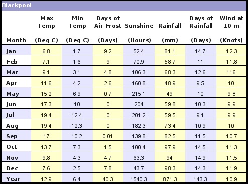
YeaR 11 HOMEWORK HELP
it's quite hard to find a climate graph for Blackpool - why not use this data to draw one or make one in excel?
remember we need temperature as a line graph and rainfall as a bar graph
This week saw the eruption of the world's most active volcano...
Well done Y11 - Geography controlled assessment superstars
thought you might enjoy this little video.......
Year 10 Parents Meeting: Thursday March 3rd 2011
Don't forget to remind your parent's that we have a meeting on Thursday night at 4.30 to discuss our adventure weekend to Hawes End. Please tell your parents that the meeting is in the Drama studio not the LRC
Year 10 Montserrat
some more info on Montserrat:
http://www.sln.org.uk/geography/schools/blythebridge/GCSEMontserrat.htm
http://news.bbc.co.uk/1/hi/scotland/edinburgh_and_east/6968496.stm
http://news.bbc.co.uk/1/hi/sci/tech/3687700.stm
and some pyroclastic flow stuff.......
S